Tuesday, August 13, 2013

Days 37, 38, 39 - Chicago


"Look its simple.  Whatever mileage we put on, we'll take off"
"How?"
"We'll drive home backwards."
Ferris Bueller's Day Off

This is getting posted a little late, but I during my 10+ hour drive to Williamsport today, I did not want to waste any time.  Chicago blew the competition out of the water (not that these cities were ever really intentionally competing for my affection).  The drive in went surprisingly well, especially after my host warned me that GPS units often get confused in Chicago, and we all know how well Siri does under pressure.  After being attacked by a gang of 20 people on crotch rockets on US-55 I made it to Liz's apartment in the Lake Shore East neighborhood of Chicago.  The first view of the city was marred by clouds, so my initial impression was not great but the clouds disappeared as I got into the city and wow was all I could say.

But first, my host.  Liz and I met on the bus on our first day of high school, and after a few days of harassment from her we became friends.  Liz currently lives with her boyfriend Mike whom she met at Jefferson Medical College.  They are both just starting 4th year of residency, Liz in Pathology and Mike in Anesthesiology.  I could not have asked for a better place to stay, as their apartment sits on the 25th floor of a building facing Lake Michigan with Navy Pier on one side and Millenium Park on the other.  Liz and I caught up and then the three of us made our way to Lincoln Park to walk around and check out the free zoo.  Since it was a long day and they both worked the next day we relaxed back at the apartment and enjoyed some deep dish pizza.  I know there is great debate about what style of pizza is better, but I say they are not comparable and should both be equally enjoyed.  My bed was set up against the large window in their living room, and I slept under the lights of the city as if I were back in Canyonlands under the stars.  

The next day Liz and Mike went to work and I was left to wander around the city.  After having a coffee and enjoying the most recent episode of Breaking Bad I headed out into the urban jungle.  This is a complicated city to walk around as there are multiple levels and you can easily find yourself in the underworld very easily.  Naturally I got lost a few times and thought I'd never see the light of day.  Fortunately though I did not become some underground world dweller set on taking over the city (see Dark Knight Rises) and found the river and Navy Pier.  Navy Pier is the tourist district with shops, resturanants, an IMAX and children's museum.  I had lunch at Harry Carays and then bought a ticket for an architecture tour.
Ferris Wheel at Navy Pier
The architecture tour is apparently the thing to do when visiting Chicago as the river makes for a great way to view the widely spaced apart skyscrapers.  For $30 you get an hour ride on a river boat with a guide pointing out the various buildings and talking about their history.  Having been mostly destroyed in the 1871 Great Chicago Fire, Chicago became the the birthplace of steel-framed buildings and skyscrapers.  The highlight of course was the Willis Tower, formerly the Sears, now the second largest building in the US.  Our tour guide was entertaining, but certainly would have rather had Vince Vaughns character from the Break-Up.  

Next up was stop to check out the "Bean" the giant mirror sculpture in Millennium Park.  This was a very crowded place so I did not even attempt to get a picture without people in it.  Unfortunately my time was cut short by a summer afternoon shower.  In my attempt to get back to Liz and Mikes apartment I again got lost in the underworld.  There was a lady smoking a cigarette down there.  Now if this were Boston, New York or Philly I would not even consider asking for directions but this is the midwest and man was she friendly.  She gave me multiple options to get out including scenic ways vs the quickest.  The lesson here, get over yourselves east coast cities.  

Feeling as though I had seen enough of the city I only had one thing left to do in Chicago and that was go to a baseball game at Wrigley Field.  The benefit of a team being in fourth place in their division is that you can get tickets easily.  I bought some using the MLB app, with the tickets get loaded directly to my passbook and once Liz and Mike got home we headed to the game.  Only Fenway is older than Wrigley by 2 years, and seeing a game in such a landmark was pretty cool.  The game itself was lame and being an old structure there were tons of view obstructions, but either way I can now check that off the list of things every American should do once.


The next morning I woke up early and made the longest day trip without stops of the whole trip, a 700 mile venture along I-80.  Indiana and Ohio are the worst, as they entire drive is toll roads, with multiple tolls.  It ended up costing $25 just to drive on their awful highways.  Speaking of highways, this is just an observation (no judgment) but I noticed that the Blue States speed limits are much lower than the Red States.  One might say because the Red States are freer and another may say because people just want to drive through them as quickly as possible.  Again, no judgment from me.  Many of you may be wondering how it is that I made it home on day 39 but have been referring to this as a 40 day trip the whole time.  Technically the trip did not start until I was in Allentown.  I won't actually be there until the morning of day 41 (so 40 days and 40 nights).  I'll have one last entry then to wrap up this amazing adventure.  As always thanks for sticking around, the blog hit 4000 views yesterday!

Miles: 10,002
States: 25 (PA, MD, WV, VA, TN, NC, AL, MS, LA, TX, NM, AZ, UT, NV, CA, OR, ID, MT, WY, CO, KS, MO, IL, IN, OH)
National Parks: 17
Miles Hiked 95 (not including urban hiking)

PS. This is what I came home to and will be doing all day tomorrow.


Saturday, August 10, 2013

Day 36 - St Louis


"Supposing is good, but finding out is better"
Mark Twain

My second last stop of the trip took me to the opposite end of Missouri to St Louis.  I departed Kansas City, poorly fed by a terrible continental breakfast and made my way east along I-70.  I must admit I did not have much planned for this last leg of the trip.  I figured I'd just show up at cities and find stuff to do.  In regards to St Louis, all I knew was that I should see the arch.  I made good time into the city, stopping only once to fill gas and get lunch, which happened to be at the Wendys of the future.  I know most people do not care to hear about a fast food establishment, but this Wendy's had a fireplace, a computerized soda dispenser, 2 story ceilings, fancy mood lighting, and couches.  Not that any of that made a difference, my Baconator was as delicious as ever.  


After 4 hours I made it to the Mississippi River and sat in a line of traffic to the parking lot for the Gateway Arch.  Prior to getting there I had been warned it'd be anti-climatic, but it was still a pretty impressive structure.  The arch stands at 630 feet and is the tallest national monument in the US.  It was built as a symbol of westward expansion and, as is St Louis, considered the gateway to the west.  For me it was the opposite, a bit of a welcome back to the east.  St Louis actually had the feel of Philadelphia in many ways and I felt more at home here than any of the other cities I had been to on this trip.  The arch is part of the larger Jefferson National Expansion Memorial and is operated by the National Park Service.  This was great news to me, as my America the Beautiful Park Pass got me to the top at a discounted price.  The lines were very long though and when I got to the ticket booth, the next available spot was not for another 2 hours.  However, when the lady found out it was just me, I got sent to the very front of the line.  Single people are apparently much easier to work with.  For those who have never been here, the way up is via a tram.  This is quite a process, as they take up to 4000 people a day in the summer to the top, a space only 7 feet wide that can fit 160 people at most.  The ride up takes about 4 minutes.  It is not meant for the claustrophobic types as the tram is a collection of capsules each with only a 5 foot diameter, and fits just 5 people sitting with knees scrunched together.
Capsule to the top of Gateway Arch
I made it up to the top only 20 minutes after parking and quickly found hell on earth for someone not crowd friendly.  Imagine being 630 feet in a room only 7 feet wide with 160 people, many of which do not understand any English or general rules of society for that matter and kids.  I like kids, but not ones who are scared out of their mind and scream bloody murder than entire time in a very confined space.  I took a few pictures out of the tiny windows and then got in the first line I could to get down.  Fortunately not being part of a group allowed me to squeeze onto the first tram down.  After getting down to the ground, I wandered around the area and over to Busch Stadium where a game between the Cardinals and Cubs was about to go down.  This town loves its baseball team.  A pending baseball game, meant more crowds, so I decided to head to Forest Park about a 5 minute drive from the Arch.


Forest Park is considered the "heart of St Louis" and rightfully so.  There is a ton of stuff to do here and most of it was free.  The park has a zoo, art museum, science center, golf course and lots of space for other recreational activities.  Since I had not seen as much wildlife as I had hoped during this trip, I opted for the zoo.  The zoo, free due to public subsidies, is a top-notch zoo.  Again I was impressed.  The only struggle I had was trying not to look like a creep, wandering around alone in a hat, sunglasses, creepy beard and camera.  I wanted to take pictures, my hair was crazy without a hat, and I was about to shave the beard, so sunglasses had to go.  I squinted my way through.  It was getting late, so I called it quits and headed to my hotel in the Southeast area of the city.  I used Trip Advisor to find an awesome Pizza Bar in Kirkwood, a wealthy suburb of the city.  Another Trip Advisor success.  If you do not have this App, get it, it'll change the way you travel.


It was another satisfying day.  Tomorrow I head to Chicago, the final stop of this 40 day voyage.  

Stats:
Miles Driven: 8,964
States: PA, MD, WV, VA, TN, NC, AL, MI, LA, TX, NM, AZ, UT, NV, CA, OR, ID, WY, MT, CO, KS, MO
Baconators Eaten: 4
Grizzly Bears Seen: 1 (FINALLY)


Friday, August 9, 2013

Days 34 and 35 - Denver and Kansas


"Everything that has a beginning has an ending.  Make your peace with that, and all will be well"
Gautama Buddha

I guess we've finally come to the concluding leg of this trip.  I've been on the road for over a month and its time to head back.  I last left you at a coffee shop in Boulder.  Shortly after submitting my post, I headed south to Denver where I stayed with Ian Case.  For those who do not know, Ian and I go way back to Kernsville Elementary school and Indian Guides.  He moved out this way for college and has stayed out here since.  Its understandable why someone would have trouble leaving this area.  The Rockies are Denver's backyard with endless possiblities for outdoor activities.  

I got into town fairly late, we caught up and then called it a night.  Ian worked the next day, so I had to find my own trouble.  I started the day with breakfast at a small diner in the southern area of the city.  Its a fairly large city and where Ian lives is a few miles from the main down town area.  Not feeling like dealing with traffic and parking I opted to take the Light Rail to the 16th Street Mall, Denver's version of San Antonio's River Walk (though no river).  I figured this would be a good place to start to find stuff to do.  One of the problems once I got down there was that there is really nothing specific in Denver that you have to see.  A very friendly security guard must have sensed this and asked if I needed help.  He gave me a few suggestions including the zoo and art museum.  The art museum seemed like a good idea, so I headed to the Civic Center Park.  When I got there I suddenly remember how much I really do not like museums so instead I just walked around the parks.  There was an overcast (surprise, clouds in the sunniest city in the US when I happen to be there) so the city was not looking at its best.  I managed to kill a lot of time and headed back to Ian's and waited for him to come home.

After resting for a bit, it was time to head back out.  Ian, myself and one of his work buddies headed downtown for dinner at the Wynkoop Brewery and then a fairly tame evening of bar hopping.  Denver is an interesting city.  It does not seem to have a well defined culture like San Fran or New Orleans.  Its population seems very young and physically active (runners and bikers everywhere) but somewhat homogenous.  There are a ton of bars and restaurants and then that's about it.  Oh and it smells like marijuana at night time, after all it is the first state to legalize it. There seemed to be medical marijuana suppliers everywhere.  And thats about all I learned from Denver.  Though my intentions were really to visit Ian.  It was great catching up, as we've only seen each other a few of times over the last 11 years.

The next morning, I left and made my way to Kansas City.  I had been warned this drive would be terrible.  I set up my route on my phone and sheer dread came over me when Siri's voice came on and said continue on this road for the next 579 miles.  That was my day today, nearly 10 hours of driving through one of the flattest states along the straightest section of I-70.  All I could do to get through it was listen to Comedy Central, play about all the music I have and reminsce.  In doing so I came up with 10 things from this trip that I'd rather be doing than driving through Kansas.  And here is that list.

10. Ride the Skylift above Gatlinburg, TN
9. Eat charbroiled oysters at Acme Oyster House8. Play Small World with Jake and Jess while drinking good California wine7. Hike in a storm with roaming buffalo in Yellowstone6. Watch the sunrise light up the stone structures in Arches5. Eat my peanut butter and jelly sandwich on top of Clouds Rest in Yosemite4. Lie on the roof of my car and watch the stars at Dead Horse Point3. Listen to jazz live at Preservation Hall in New Orleans2. Jump off the cliff into Crater Lake again and again1. Drink a Teton Ale while watching the sunset over the Grand Tetons


I survived the drive and made it to Kansas City.  It was a very uneventful drive, that may have included a conversation with Siri.  If you have an iPhone ask Siri to tell you a story.  Once I arrived in KC, I only had one goal and that was to get some good BBQ.  I opted for the Woodyard Bar-B-Que, one that I had seen featured on Food Network and had wanted to go to when I was in KC last year.  It lived up to the hype.  After a nice meal outside, I headed for my hotel near the airport.  I did not have anything that I wanted to see in KC and after the long drive just needed a place to crash.  Tomorrow I head to St Louis and then after that Chicago before finally heading home.

Stats:
Miles Driven: 8,790
States: PA, MD, WV, VA, TN, NC, AL, MS, LA, TX, NM, AZ, UT, NV, CA, OR, ID, MT, WY, CO, KS, MO
License Plates Left to Be Seen: Hawaii, North Dakota and Rhode Island


Wednesday, August 7, 2013

Days 32 and 33 - Rocky Mountain National Park


Roads... Where we’re going we don’t need roads
Back to the Future 2

At least that’s what Siri decided.  I know I’ve voiced my frustration with the Apple voice a few times during this blog and now that I’m calmer writing, I realized its still a pretty miraculous thing that I can just tell a 4x2 inch piece of metal and glass to take me to Rocky Mountain National Park and it’ll do so.  That’s how my day started in Moab, a stop at the motels continental breakfast, a gas refill and then getting my directions for the day.  The plan was to go North to I-70 and take that into Colorado.  It was a sunny day in Moab with endless possibilities of fun, but it was time to move on, the reality of life is only a week away.

The drive into Colorado was easily one of the most beautiful of the trip.  It had been a while since I had seen true east coast greens.  The west is pretty, but lacks the mosaic of greens that you see out in Pennsylvania.  The transition was neat because the mountains and canyons start off red and pink and slowly get engulfed by plants.  It was the closest feeling to be being back home that I’ve had.  Except, Colorado is like Pennsylvania on steroids (not that states can take steroids, that’s only professional athletes).   There are mountains everywhere and the Colorado River seems to be omnipresent.  Route 70 travels along the base of these through mountain tunnels with views of the Colorado’s rapids and the people rafting down it.  Random side note here, Sisqo’s the Thong Song was playing during one of these mountain tunnels, and while I lost XM reception for about 1 minute going through them, I was able to continue the song and get back into it with impeccable timing.  Classic song.

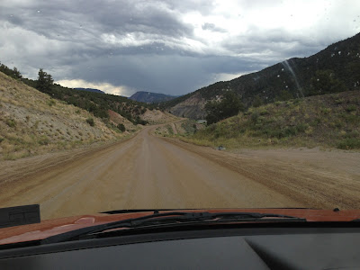
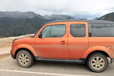
All was going well until Siri’s voice interrupted my self ramblings and told me to exit and turn left onto Trough Road.  I always like to double-check her, so I looked at the map overview and it appeared to be the only direct road connecting to the highway to Rocky Mountain NP.  Trough Road is a 25 mile death trap.  It goes up and down the mountains along a dirt road with turns around cliffs without any guardrails.   There also happened to be a nice storm going on throughout all this.  There is no reception in the area, so I could not even curse at Siri and hear her respond, “there’s no need for profanity.”  There were other cars so I felt slightly better, one even waved at me.  Then I passed by a sign that just said “DANGER” and I began to wonder the friendly driver was warning me or saying goodbye.  I’m not sure what that sign was specifically referring to but it may have been the steep decline with 180 degree turns, the potholes or my least favorite the fallen rocks the size of soccer balls lying in the middle of the road.  I even saw one fall, which I’ve always thought those Falling Rock warning signs were just a bluff.
 
Trough Road
Obviously I survived, and wouldn’t you know that the second I turned onto a real road, the storms stopped and became just a nice gray overcast.  I continued along and eventually reached the park.  I was feeling tired and it was gloomy out so my plan for the day was to just enjoy the Trail Ridge Road drive.  This is the highest major highway in North America, reaching a peak height of 12,183 feet.  The terrain actually becomes Tundra, the light purple-colored areas on a climate map (thank you elementary school) at these altitudes.  The park has 72 peaks above 12,000 feet with the highest being 14,259 feet.  Too bad I could not see any of them in the cold fog that had settled in the mountains.  I did not let this get me down, satisfied with all I had seen in the past month.  Plus when you are driving up to 12,000 feet along a road that also does not have guardrails and you only want to look at the road.  All my acrophobia came back, and both hands remained glued at the 2 and 11 oclock positions.  A single sneeze, forcing my eyes closed, could have led to my demise.  The double sneeze I happened to have around a bend was terrifying. 
 
The aftermath of Trough Road
I arrived at camp, which was full, but I had a reservation.  The majority of the camping I have done I booked campsites through Recreation.gov and it has worked out amazing.  Most were booked in March.  If you plan to go to any parks, and you should, use this site.  I also recommend the Fodors National Parks of the West for great insight into the best campgrounds.  I set up camp, made dinner, read and planned the next day.  The forecast for Wednesday was 70% chance of rain, but when morning came the sun was shining.  So I headed out for a hike.  The area is so popular for hikes that they have parking lots just to get on shuttles to the trailheads.  I decided to head to the Bear Lake area which had a few trails to lakes and waterfalls.

The sun was no longer shining by the time I hit the trail, so distant views of snowcapped mountains was not in the cards.  Instead I focused on the smaller details of an alpine mountain trail.  Like the Sierras wildflowers were abundant in bright colors against the dull gray backdrop.  Though initially gray the big boulders up close are covered in green, white, orange and black lichen appearing as a natural graffiti.  Speaking of graffiti, the small aspen trees were covered in keloid-like scars from years of people etching their names on them.  Not to go all Fern Gully on you a, but this defacement of trees is something that I do not understand.  And not because the tree has feelings, just because it looks ugly and what is so special about that moment you feel the need to engrave your initials on a random tree.  Even my favorite tree (yes I have a favorite tree) that sits in my parents yard has no carvings in it.  The hike was an easy 3.6 round trip to another Emerald Lake that sits at my highest altitude hiked to at 10,080 feet.  After returning I picked up another 2 miles of hiking to a small waterfall.  It was early afternoon at this point and I had seen enough for the day so decided to make my way into civilization.


The next stop on the trip is Denver, but my host would not be home until 9 PM, so I had some time to kill.  I first stopped in the touristy town of Estes Park, a town at the eastern edge of the park, similar to the other national parks gateway towns.  I had BBQ at Smokin Daves BBQ and then made my way through the rain to Boulder.  Boulder is a place where real world problems do no exist.  The sun was even shining just over Boulder.  I stopped in town, paid a very reasonable price for parking, and got some coffee so that I could use the WiFi to send off this blog.  The population looks more normal than I thought they would.  My mind predicted everyone would look like Courtney from Season 12 of Survivor (google image her).  Only about half the people, men and women, look like her.  Despite the endless jokes I could make about this town, it is actually a very beautiful town. 

However, enough about cities, today marked my last day in the National Parks.  No more days without showers, sleeping on the ground or removing everything with a scent from my car.  I’ll miss them though.  Life is simpler, once you get away from the crowds up into the mountains or out into the desert.  I’m not a fanatic, or someone who would chain himself to a tree, but its nice to get away.  John Muir may have said it best when he said “Climb the mountains and get their good tidings. Nature’s peace will flow into you as sunshine flows into trees.  The wind will blow their freshness into you, and the storms their energy, while cares will drop away from you like the leaves of Autumn.”  He did leave out, but be careful because there are bees out there and they will sting you if you get too close to their wildflowers.  I learned that the hard way today.


Stats:
Miles Driven: 8058
States: PA, MD, WV, VA, TN, NC, AL, MS, LA, TX, NM, AZ, UT, NV, CA, OR, ID, MT, WY, CO
Blog Views: 3737
National Parks: 17
Miles Hiked: 95
Highest Altitude: 12,183

Tuesday, August 6, 2013

Days 30 and 31 - Arches and Moab


"Travel and change of place impart new vigor to the mind"
Seneca

Its hard to believe its already been four days since I dropped Shriver off at the airport, the trip is really going fast now.  I last left you at the edge of Dead Horse Point.  The experience of traveling alone has made this a whole new adventure that I am thoroughly enjoying.  There is only one thing that will prevent me from continuing on and that's hunger.  The morning of Day 30, having had to eat a dinner of dried apricots, almonds and beef jerky the night before, my stomach was the captain.  The nearest town to Canyonlands is Moab and since that was in the direction of Arches, I headed there first.

The town of Moab sits about 6 miles south of Arches and serves as the main hub for outdoor activities in the area.  Along its main street are numerous outfitters that will whisk you away on 4 wheelers across the slick rock desert, on a raft to try your luck on the Green and Colorado River or take you up in the air for a view of the canyons and arches.  The general area is a mecca for mountain bikers with world class challenging tracks.  In the mix of things are eclectic restaurants and bars with names like Love Muffin, Wake and Bake Care, and even one named Eklecticafe.  I chose the last for a hearty breakfast of eggs and biscuits with gravy.  Satisfied I headed out into the heat for some arch viewing.

The first stop was Corona Arch which is actually not in Arches National Park.  This hike was recommended to me by the two ladies at Squatters in Salt Lake City.  I filled up the gas tank and headed down a road along the Green River and after about 10 miles came to the trail head.  The hike was a relatively easy hike by elevation and length standards, 3 miles round trip with 350 feet of climbing.  Of course it would be easy if it were anywhere but the desert, the heat is brutal here and it is recommended you carry at least 2 liters of water with you at all time.  It ended up being a fun hike along the slick rock, with sections requiring cables and ladders to get to higher elevations.  There was a storm brewing in the distance, which in addition to ruining my camera would make the hike back much harder as when slick rock gets wet it gets slick, go figure.  I arrived at the arch.  This arch is a fairly famous place to rope swing (http://www.youtube.com/watch?v=4B36Lr0Unp4) standing a 100 ft above the trail and 140 ft wide.  There were two people on top of it with ropes so I was hoping I'd get to see someone swing but they never did and the storm was approaching.  I hurried back and got to the car just in time. 
Corona Arch
The next stop was Arches National Park.  Arches is a relatively small park at 79,000 acres and is home to the largest number of sand stone arches in the world, with over 2000.  The most famous, Delicate Arch, is found on the majority of Utah drivers' license plates.  The park was not overly crowded, which was good because it is mainly a driving park with roads going right up to some of the arches.  The park is more than arches though, it has large sand stone monoliths sculpted over time by rain and wind.  If it were not for the bushes and scattered trees you could easily have told me I had made a wrong turn and ended up on Mars.  This place is not Earth.

My campsite was at the northern most point of the park next to the Devils Garden trail, so I decided to spend this afternoon hiking to Delicate Arch.  There are two options to getting to the arch, a drive to a view point or a 3 mile hike that takes you directly to the arch.  I chose the latter.  It was about 3 in the afternoon at this point and the sun was nice and high over head beating down the entire hike without any shade.  I made it up quickly and rested with an awesome view of the arch with the mountains and canyons in the background.  I made it back to the car with some water to spare and moved on.  After a few more stops, including Balancing Rock, I headed to my campsite.


The campground was one of the most unique I had been to.  Each site was tucked up against giant slick rock boulders providing lots of exploration and rock scrambling.  I was not going to go without a heated dinner so my first priority was dinner, but I got distracted reading a book I had picked up in town called the Last Season, the story of an elite search and rescue ranger who himself went missing in the Sequoia and Kings Canyon wilderness.  By the time I was ready to cook, a small storm had made its way to the campground (surprise).  Fortunately, cooking already cooked rice and salmon was easy and I had a nice dinner at the back of my car with a tarp rigged around me to block the sideways blowing rain.  I went to bed early for a planned sunrise hike in the Devils Garden.


Waking up prior to sunset is very difficult, because this for some unknown reason is the easiest time to sleep.  I managed to fend off the urge to hit the snooze button and got up at 5:45, 30 minutes before sunrise.  I packed up camp, ate two granola bars and an apple and headed to the trailhead.  When I hit the trail I only had 5 minutes before sunrise and had a quarter mile to get to the first arch.  I power walked to it and managed to get a few awesome shots of the sun rising over the canyons and lighting up Pine Arch.  After some pictures, it was time to move on and check out the other 8 arches along the 6 mile round trip hike.  The most impressive was Landscape Arch, a nearly 300 ft long arch that is at its narrowest section only six feet of rock wide.  In 1991 a giant 73 foot slab of rock fell from the arches and was caught on film by a tourist, a reminder that these structures are all bet temporary.  After this section, the trail became semi-primitive.  It led up fins, buttes and through open sections with only cairns to lead the way.  This became problematic for me as my self-diagnosed ADD was in full swing and I was not paying much attention to the cairns.  I got lost, following a sandy path along the slick rock.  I was first on the trail so I had no one to follow, there was a couple not too far behind me initially so when I realized I had not seen them in a while, it was time to retrace my steps.  On the way I happened upon a snake that based on the shape of his head and my cub scout training I determined to it to be nonvenomous.  However, sharks and bears aren't poisonous either, and we keep our distance from them (they all still bite) so I waited a few minutes and threw a rock near it to get it to move (crisis averted).

This is the problem with using piles of rocks as trail guides in an area known for its rocks.  Fortunately I was able to retrace my steps and only add about half a mile to my hike.  During my mix up a large group of French tourists had caught up to me and asked for directions (isn't it ironic, don't you think?).  Anyway, now an I expert I lead them in the right direction, I think.  A little side note here, since as long as I can remember, its been engrained into me that Americans are awful tourists.  Well if we are awful, what does that make the French.  This group of about seven (all adults) were loud the whole hike and walked over fragile plants.  I could hear them a mile away and when they got to an arch, they'd yell words like "stupid" to hear it echo.  Additional side note, arches don't echo.  Anyway, back to my hike.  The hike ended at a collection of spires and then it was time to turn around.  My trip back made me me happy I had woken up so early, as this is a very popular hike.  The last family I passed before getting to my car was in the middle of a breakdown, mom was crying, kids looked cranky and dad didn't seem to care.  It's nice being alone sometimes.

Afterwards, I hit up Moab stopping at the Wake and Bake for lunch and then the Moab Brewery for dinner.  As always I sat at the bar and chatted with fellow tourists and townies.  One particular guy worked in film production and told me about the number of movies made in Moab, some of my favorites.  The list included Indiana Jones and the Last Crusade and Raiders of the Lost Ark, Thelma and Louise, City Slickers 2, Con-Air, Mission Impossible 2 to name a few.  After dinner and some beers, it was off to bed to get ready for the next part of the trip to Colorado.  Utah was awesome though, a state with a diverse landscape and super nice people.  The possibilities for adventure are endless in this state.  
 
Pine Arch

Stats:
Miles: 7510
States: PA, MD, WV, VA, TN, NC, AL, MS, LA, TX, NM, AZ, UT, NV, CA, OR, ID, MT, WY
Favorite State: Utah
National Parks: 16
Miles Hiked: 90
Bottles of Water Drank: 16
Urine Output: 300 ml (completely made up statistic, but it was very low)